|
The Mysterious Indian Hut
 Nobody
seems completely sure as to what it was or what it looked like
- but it appears on old maps as a prominent landmark. Nobody
seems completely sure as to what it was or what it looked like
- but it appears on old maps as a prominent landmark.
Long disappeared, but not completely forgotten,
the Indian Hut has from time to time provoked discussion and disagreement.
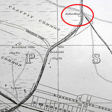
The one thing we know for sure is that it appears
on local maps of the area during the last thirty years of the
19th century. Its location was what would now be the junction
of Green Road and Charminster road - just south of the Fiveways
pub.
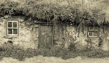
It was generally described as a rough cottage, in
some disrepair, occupied by a swarthy looking tramp. There was
speculation that he was either Indian or a soldier who had once
served in India. Neither seems particularly likely.
Another explanation comes from writer Pascoe Marshall.
He says, "In the early days of the eighteenth century smallpox
broke out in the villages and up this track at a spot where the
Fiveways Hotel is now, was built a wattle and daub hut as a primitive
isolation hospital, the patients were taken there and more or
less looked after themselves. This structure was called Indian
Hut and the name was still used by us natives until the Fiveways
Hotel was built; what a chance was missed for preserving a name
with a history".

From an 1893 map |
The building was already known as the Indian Hut
in the 1861 census, and at that time was inhabited by a family
of four - 53 year old labourer John Lockyer, his wife Mary Ann
and two sons. A sign of the poverty of the times is that ten years
earlier Lockyer was living in nearby claypits on Parish relief.
Twenty years later his son John was apparently doing time at Pentonville
Prison for felony.
The original Indian Hut disappeared under the building
developments of the early years of the last century. The last
known reference to it appears in the Bournemouth Graphic in a
1906 article on the opening of Queens Park Drive.
A year earlier a reporter from the paper had set
out to find the Hut. He described wending his way down the hill
from the Richmond Hotel, through heathland and past a gravel pit:
"We are not surprised that we never came across
the Indian Hut before in our rambles. It certainly took pains
to hide itself well away from the haunts of men. There is only
one floor, and above, a long thatched roof with here and there
patches of grass peeping out. An old square chimney surmounts
the roof, and is the only brickwork perceptible. The walls are
rough, the windows low and square, and painted by some unhappy
inspiration a bright yellow. Around the hut stand a few Scotch
firs, and in the garden, leading down to the little wicket gate,
bloom a few chrysanthemums."
To add to the mystery, the route he describes appears to take
him past the spot marked on the map - and on to the small original
settlement of Charminster a couple of hundred yards further north!
In yet another confusing turn - the name of the
Indian Hut survived through a tobacconists shop in Charminster
Road - a little bit further south of the original location. It
seems that when local residents recall the Indian Hut, and in
particular visits to get ice-cream or lemonade, they are referring
to the shop and not the building that preceded it. The shop bore
the name "Indian Hut" and even had a life-sized statue
of a Red Indian chief outside.
It is probable that the name Indian Hut may have
been applied to several different buildings in the area of the
past two hundred years. The only thing that is certain about it
is that it was a place on the map and that people lived there.

Proof of habitation - the 1861 census entry |
|